

Woodborough’s Heritage
An ancient Sherwood Forest village, recorded in Domesday
The Old Vicarage & former school
Introduction to, and historic survey of, the Old Vicarage
The Trent & Peak Archaeology Unit was commissioned by Fowkes McIntyre Architects on behalf of Mr & Mrs Hursthouse to carry out a historic buildings survey of the Old Vicarage at Woodborough, Nottinghamshire. The property is situated on Lingwood Lane, close to St Swithun’s Church in the centre of the village. It consists of a range of structures, built or added during the 18th-20th centuries, along with outbuildings. Although not a listed property it, together with its outbuildings, is included in the Borough of Gedling’s list of ‘Local Interest Buildings’. It is of historical significance in the village, having originally been a foundation school. It later became the vicarage and is now a private residence. There are currently proposals to make architectural improvements to parts of the building [2006].
Much of the following is taken from their report which is based on a site visit when the building was analysed and photographed. Accurate plans and elevation drawings produced by Greenhatch Limited were supplied by the architects and are included in the report. Individual rooms have been divided into components parts A-D for ease of explanation. Selected views from an archive of digital photographs taken during the site visit are included later. Some complementary documentary research was carried out at the following places:
- Local Studies Library, Hallwood Library, University of Nottingham.
- Local Studies Library, County Library, Angel Row, Nottingham.
- Nottinghamshire Archives (NA).
- Consultation with local historian Peter Saunders.
Summary of Key dates:
- 1736 became a school:
- 1878 it became a vicarage:
- 1961 a private dwelling, hence the title 'Old Vicarage'
Most of what is known about the history of the Old Vicarage is derived from the writings of Rev’d Walter Buckland, whose detailed history of the village was published in 1897. He provided the original date of 1736 and the internal dimensions of the schoolroom and a so-called cottage part. He also listed who made subsequent changes to the building, many of which can be identified in today's structure. Specifications for work carried out in 1879 at the change of use, can also be seen. Structural analysis of the building had identified about six major changes to the property, many associated with the different schoolmasters who both lived and worked in the building. The plan and appearance of the building has changed little since the end of the 19th century.
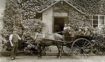
Above left & right:The Vicarage in 1914 & 1915 respectively. Right: Photographed outside the front door on the north side shows Peter Foster (an uncle of Mannie Foster) with the Rev’d Birch-Jones and family. A previous owner of the vicarage (2001) used this photograph to aide the design for new carving over the doorway.
The original schoolroom and cottage were situated in the central part of the building. This part was later heightened, widened and newly fenestrated in the late Georgian period by Samuel Oldacres. Since 1879 this schoolroom has been used as a kitchen and the cottage part used as the dining room.
The school was provided with a new larger schoolroom before 1785 by his predecessor, Richard Oldacres. This was set between the existing building and Lingwood Lane (where it may have replaced an earlier structure, the footings of which still show). It had two upper storeys with bedrooms for boarders. This part of the building remains largely in its original form, and probably still retains original roof timbers which might provide confirmatory tree-ring dates. A small kitchen block with cellars was added to the west end of the 1736 building. The Enclosure map of 1798 suggests that other ancillary buildings may have been added to this.
Other changes were made after 1840 by another Samuel Oldacres, mainly to the west end of the property, including the building of a tall round clock-tower [actually a bell tower referred to as The Pancake Tower]. After the change of use in 1878, the north-east part of the building was altered and new services rooms built when the kitchen was moved from its former position to the former schoolroom. The former kitchen became a study. A conservatory [lean-to greenhouse] was later added, since replaced by a modern ‘sun loggia’. There are currently proposals to replace and alter this part in a more traditional style to compliment build [2006].
Historical Background
The School years 1736 - 1878: Most of what is known about the Old Vicarage is derived from the writings of Rev Walter Buckland whose detailed history of the village was published in 1897 (The History of Woodborough and of the Prebendal Church of Woodborough in the Peculiar of Southwell. Nottingham). He will have occupied the building which he disparagingly described as “an ill-arranged and badly-built house which is situated in a damp position right on the village dyke or sewer” (ibid. 80). According to Buckland the house had originally been where Rev’d Montague Wood (Rector of St Michael Royal in London) had established a foundation school for the village in 1736. It then consisted of a schoolroom 18ft 6ins by 14ft 6ins and 8ft 6ins high (5.6m x 4.4m x 2.6m), and a cottage 18ft 6ins by 16ft wide (5.6m x 4.9m), divided into a parlour 10ft by 9ft (3m x 2.75m) and a kitchen with an open chimney, a small passage and staircase. The original schoolroom accommodated 27 scholars (Marriott 1892, 10). Deeds established that a building was erected with bricks from Calverton Brick-pit at this date; the local pit was not in full production until the 1770’s [Peter Saunders].
The first headmaster of the endowed school was John Thorpe (1736-1763), followed briefly by a Mr Wildbore and then Richard Oldacres, who became Schoolmaster and Stipendiary Curate in 1771 (Bagley et al 2000). He enlarged the building so as to take boarders by building a new schoolroom 23ft wide by 19ft 8ins deep and 8ft 9ins high (7m x 6m x 2.65m), and a study adjoining with two storeys of bedrooms above, and two cellars, a kitchen and pantry above and a bedroom overall (Buckland 1897, 87). When he died in 1785 he was succeeded by Rev’d Samuel Oldacres (1785-1812), who Buckland claimed had rebuilt the school and further enlarged the house, at a cost of £300 and had erected a stable / coach house (Buckland 1897, 87). However, after Rev’d James Hewes (1812-1837) the Rev’d Samuel Lealand Oldacres (1837-1876) occupied the school and he is said to have done something similar – rebuilding the whole of the original school except the outer walls, enlarging the house, and building garden walls, conveniences and a new stable / coach-house. Although both men undoubtedly made changes to the property there may be some confusion due to the similarity of names as to who did what. It seems unlikely that both would have rebuilt the stable / coach-house, for instance.
A new Education Act was passed in 1871, and in 1875, when the school has 63 children attending; a Government inspector condemned the school as not meeting Government requirements. The school could be retained as a Church School under Government control but Rev’d Oldacres objected to this on the grounds that the Church would retain overall control. Following a public meeting it was decided that a new school would be built, and this opened nearby in 1878. Oldacres retired and was provided with the former school and house for life. He died in 1876 and was succeeded by Rev’d F. G. Slight who bought the old school and house to become the vicarage of St Swithun’s Church.
The Vicarage years 1878 - 1961: Rev’d Slight was granted money to carry out improvements to the building, and local architect and namesake George Henry Slight drew up plans in 1878, some of which survive. A specification at Nottingham Archives (ref. SBX121/8-9) lists alterations to be carried out. These were mainly on internal changes to doors and chimneys and changing the kitchen and scullery into a new study and the old school into a new kitchen. The main changes were as follows:
- Take down present stable, coach-house and lofts, leaving only the end wall towards the house to receive the roof. Take down yard walls and coal house. Take down buildings forming the back yard of old school, leaving the wall towards the public road untouched. Remove old privies. Build new addition shown on plans (plans now missing).
- New Study (now kitchen and scullery). Take down old stack, build new chimney. Make cuts for new window in end and make door.
- New Kitchen (now school). Take down interior partitions now forming closet and classroom. Remove old fireplace in classroom. Make new addition for pantry, china closet and back entrance, scullery and yard, also build kitchen chimney and wall, scullery fireplace. Provide roof of scullery shed in yard and roof over new WC. Provide scullery with force-pump.
- Tile pavement: lay floors in the kitchen, scullery, back yard entrance, sewing-room yard, servant's closet etc. Build with brick and quarry tile a milk bench in larder, repairing old troughing. Parge the new flues carefully with cow dung.
- Provide and hang bells.
- Build manure place and man’s privy. Cess-pit 6ft deep, 3ft across to receive WC and scullery drains in Stable yard and cover with York slabs.
The outline of the vicarage shown on the First Edition 25 inch scale Ordnance Survey map of 1883 has not changed much since 1878. A conservatory, or more likely a lean-to-greenhouse, was added at the south-west corner before 1900 and this was replaced by a modern flat-roofed ‘sun loggia’ structure in the early 1970’s. It is now proposed this is to be removed and to build a new structure more sympathetic to the main building [2006].
Stipendiary Vicars who most probably resided in the vicarage:-
1876 Frederick Good Slight M.A. Mort.
1891 Walter E Buckland M.A.
1896 Samuel Bond M.A.
1912 John Birch Jones B.D..
1919 Myles Atkinson M.A.
1930 John Richard Hooker B.D.
1933 Leslie C Rowan-Robinson M.A. Ch.B.
1947 Charles William Harrington
1950 Arthur John Evans M.A.
1957 Charles William Harrington
This 1883 OS map shows the position of the Vicarage (plot 103)
relative to St Swithun's Church (141) and the 1878 built school (99).
Building Description: The Old Vicarage consists of three main components forming an east-west range, shown on plan as A to C (see plan below), together with a service block (D) in the north-east corner. Beyond this there is a separate stable / coach-house, now used as garaging. The north side now includes the main porched entrance, facing a gravelled yard entered off Lingwood Lane. In the north-east corner there is a tall cylindrical tower with castellations and false windows. Used as a clock tower it was known locally as the pancake tower. The yard is bounded to the north by a stream. The south frontage faces a garden largely given over to lawn, divided in part by a wide ditch, once known locally as the Dell [Peter Saunders]. This is all that now remains of the sunken back lane on the south side of the village. Of some antiquity, the lane survived until the Enclosure in 1798, after which it was divided up and included amongst the neighbouring plots and most of it was later filled in.
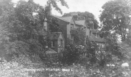
It is believed there have been few changes to the exterior of the vicarage in over 100 years, a period roughly between 1878 and 2005. A former lean-to-greenhouse made way for a sun loggia, possibly in the 1970's. 'The Dell', which formed the start of a sunken 'Back Lane' to Bank Hill is clearly seen in the foreground just beyond the shrubs. Back Lane was marked on 1795 Enclosure map.
The Old Vicarage is predominantly brick-built with a general absence of stone dressing. Some local water stones show as footings in the east end wall. The roofing is largely of tile and most of the timbers appear to be of relatively modern date. The oldest timbers appear to be concentrated in the part A, at the east end of the range. Some of the cross-beams have chamfered edges with common chamfer ends. There are few recognizably distinguished architectural features within the building apart from some panelling and some mouldings. The evidence suggests a series of alterations and adaptations to both the exterior and interior over a period of time. The plan below suggests the sequence of development of the building and alterations between 1736 and 1885.
Development of the building phase 1: The tallest part of the range, part B, central to the range, is possibly the oldest part of the building. It has the thinnest brickwork, 2¼ins x 8¾ - 9¼ins (57mm x 222-235mm) in size, laid in random coursing, and a string course runs along the south and west sides which probably went around the building. The ground and first floor brickwork on this side is consistent with a date of 1736. The stone footings visible alongside Lingwood Lane may have belonged to another separate and earlier building as the Sherwood Forest map of 1609 shows a structure on the site at that time.
.JPG)
This plan shows the probable development of the Vicarage, (now know as The Old Vicarage). The main components of the Vicarage are parts A, B, & C with B as the oldest dated 1736 and thus the original school described in phase one.
The internal dimensions of the main rooms are consistent with those given by Buckland, if the near-central south lobby-entrance, north closet and staircase above are included in what was described as the cottage. The modern kitchen is precisely the same dimensions as the schoolroom, including the height of 8ft 6ins. This is supported by the document of 1879 which refers to the new kitchen as having been the schoolroom. Part of a solid wall remains which divided this part from the so-called “cottage” area, itself partitioned into parlour, kitchen, stairs and passage. An arrangement is suggested based on the off-central position of the west-end stack and the position of the rise in the string-course in the south elevation, which could be explained by a high-level window to light a staircase. The windows in the south face are later inclusions and straight joints in the wall indicate a former doorway into the classroom. Brickwork at first-floor level suggests an earlier arrangement of windows. Both the south frontage and the internal staircase were probably altered / moved when the building was later heightened and widened on the north side.
Phase 2. The position of Richard Oldacres’ schoolroom, 23ft by 19ft 8ins and 8ft 9ins in size and built before 1785, is not that obvious. The likeliest position would appear to be area A, between the 1736 building and the street. This block, with its thinner walls, has the exact width, if not the precise length. It could easily have accommodated a study and one or more small rooms / closets in addition to the larger schoolroom. It also has two upper storeys for bedroom accommodation, as claimed by Buckland. Where the kitchen, pantry and cellars were is not so clear, but these were probably built onto the west end of block B, adjacent to the existing kitchen in area A. Bricks in part of the north-west castellations and the cellars here are consistent with the brickwork of area A. Bricks of this phase are 2¼ - 2⅜ins x 9 – 9⅜ins (57-60mm x 229-238mm) in size and are laid in Flemish stretcher bond, which is a coursing found in many 17th – 18th century buildings in Nottinghamshire. Surviving timbers in the roof structure of area A are also consistent with an 18th century date; some still display carpenters’ marks. However, the overall building had evidently extended westwards by the end of the 18th century, as the Enclosure map shows. This end, shown with a wing extending southwards, was later drastically altered. It was clearly used as a service quarter, perhaps with adjoining ancillary structures. These may have been positioned in a more irregular fashion that was not precisely depicted in the Enclosure map. Later maps from the 1830’s give reason to question the accuracy of the latter.
Phase 3. Many subsequent changes to the existing buildings appears to be of late Georgian – Regency date, which perhaps provides supporting evidence that major alterations were made by the first Samuel Oldacres before 1812, despite occurring not that long after the major enlargement in Phase 2. The main changes were made to central block, B, which was raised and extended on the north side to form a spacious corridor and staircase. This change shows well in the buildings west wall. The associated brickwork of the buildings enlargement is 2¾ins x 9¼ - 9½ins (70mm x 235-241mm) in size, laid in Flemish bond. Bricks of this thickness and still this long are consistent with an early 17th century date. Sash windows, tall skirting boards and panel doors in B probably all date to this period, and indicate an improvement of the living quarters. The corridor on the north side, the stairs and extra bedrooms provided an improvement in circulation around the building and perhaps the separation of the staff and the boarders.
Phase 4. The second Samuel Oldacres probably made a major alteration in the west end of the range, area C, perhaps extending it to increase the service accommodation and add the clock-tower. There is a clear straight joint indicating this extension. Although the outer brickwork here is indistinguishable from that used in Phase 3, there are indications of other changes, such as at the west end of the Phase 3 corridor, where a former fireplace was replaced by a new corner to link the corridor to another room, and provide a staircase to area C. This room features a distinctive motif that is repeated in the timberwork and wall edging, along with a marble fireplace and panelling, all suggestive of a mid to late Victorian date. Although Oldacres may have been responsible for this, it was probably due to Slight who, in 1879, sanctioned the making of a new study from the existing kitchen and scullery. This room would fit the description.
The other changes attributed to Oldacres are more difficult to verify, although some re-roofing and replacing of windows probably occurred at this time as many windows have panes set in the lying-pane style. New gabled windows were added to the top storey of area A, replacing garret windows in the east gable-end wall. Some Victorian case-iron fireplaces in the uppermost bedrooms may date to this period when many of the schoolchildren lived on the premises.
Phase 5. Drawings made up in 1878 probably show a suggested revamping of the building to reflect its new purpose as the village vicarage. How much of what is shown existed and how much was intended is unclear. Gothic arches in the north elevation of area B probably never existed or ever materialized. A separate building at the west may well have existed and was probably one of those removed a year later.
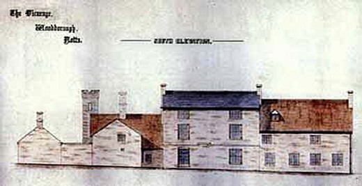
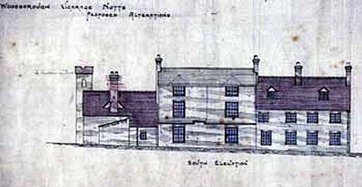
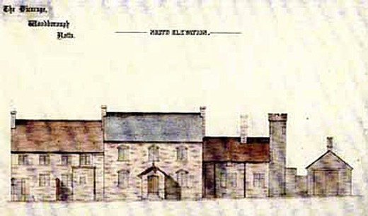
The water-colour on the left by architect George Henry Slight, shows additional buildings to the west side (left) and fewer windows than the water-colour below left by the same person, both are dated 1878.
It would seem therefore that the alterations were in accordance with the plan on the right. Note that these southern elevation paintings show no doorways.
Earlier photographs show a doorway that replaced the fourth window from the right sometime between 1878 and 1922. After 1922 another doorway was created between the windows of the central section.
This north elevation 1878 water-colour by George Henry Slight shows extensions to the west (right) of the 'Pancake Tower'.
It is most probable that these extensions were not built, if they had been then they must have been demolished at a later date.
The major structural changes made by Rev’d Slight were confined mainly to rebuilding the north-east corner, with service rooms to work in conjunction with the new kitchen. Some old privies for the schoolchildren in the formal back yard were removed at the same time. The stable / coach-house was also rebuilt, as the 1879 specification indicates, although perhaps not in its original position as Buckland later criticized this change as it obscured the view of the church from the house (Buckland 1897, 80). The brickwork of this phase is largely 2⅞ins x 9ins (73mm x 229mm) in size, laid mainly in Flemish garden wall coursing. The west extension was probably heightened at this time, or shortly after, and provided with north and south-facing gable roofs. The brickwork of these parts is slightly different to that of north-west area D, which may possibly indicate a yet later alteration, but this is speculative. They are not shown on the architect's drawings of 1878-79 seen above. Other changes may have been made by Rev’d Slight that were subsequent to the original specification.
A number of internal changes were also made to the chimneys, fireplaces and doors. The specification makes little mention of windows or roofing, perhaps because Oldacres had already dealt with such matters. Several rooms in the north-east corner are clearly identifiable from the specifications – room 3 would have been the china closet, room 3a the pantry and room 4 the scullery. A decorative truss in the latter is late Victorian in style.
Later changes phase 6: Somewhere between years 1885-1900 the south-west corner was provided with a narrow conservatory, probably for growing vines, which is shown on plans and a postcard of the period It was replaced by a ‘sun loggia’ in about 1971 [this date in doubt as a former owner has stated it happened in the 1980's], which extended further out towards the garden patio. The postcard also shows only one doorway and no doorway into area B, a situation that has been reversed since the view was taken in the early 20th century.
Mr & Mrs Poyser, former owners of the Old Vicarage from 1960 until 1996, have provided some additional information about changes to the building during their occupation.
.JPG)
.JPG)
The left photograph shows the so called ‘Pancake Tower’, photographs centre and right by Stephen Smith in 2006
shows the bell with its rope and wheel still in position inside the tower.
- The 'Pancake Bell', housed in the tower on the west elevation of the property, was still being rung on Shrove Tuesdays during the 1960's up to at least 1969. The practice ceased sometime between 1970 and 1983, now thought to be 1975 at a time during which the whole property underwent repairs following subsidence. From photographic evidence it has been established that the windows in the bell tower were bricked up and thus the bell became "insufficiently audible".
- In 1960 a door was made in the centre front although one had been there before and the door in to the study was removed.
- In the 1980's the lean-to-greenhouse was taken down and a new sun loggia was installed.
In the above left photo note the waterstone foundations. The above right nearest building was the former coach house.
.JPG)
.JPG)
.jpg)
.JPG)
.JPG)
Today, under the current owners, The Old Vicarage stands as a wonderful family home set at the heart of the village and within a sheltered formal walled garden. However, its historic and architectural significance has not been forgotten; it is noted as ‘a property of historic importance’ by Gedling Borough Council.
Acknowledgements:
- Mr & Mrs Poyser who provided some additional photographs
- Mr & Mrs Hursthouse current owners for allowing the report to be reproduced
- Trent & Peak Archaeological who prepared the report for the current owners
- Stephen Smith for his internal photographs of the Pancake bell
____________________________________________________________________________________________________
duplicate.jpg)
| Navigate this site |
| 001 Timeline |
| 100 - 114 St Swithuns Church - Index |
| 115 - 121 Churchyard & Cemetery - Index |
| 122 - 128 Methodist Church - Index |
| 129 - 131 Baptist Chapel - Index |
| 132 - 132.4 Institute - Index |
| 129 - A History of the Chapel |
| 130 - Baptist Chapel School (Lilly's School) |
| 131 - Baptist Chapel internment |
| 132 - The Institute from 1826 |
| 132.1 Institute Minutes |
| 132.2 Iinstitute Deeds 1895 |
| 132.3 Institute Deeds 1950 |
| 132.4 Institute letters and bills |
| 134 - 138 Woodborough Hall - Index |
| 139 - 142 The Manor House Index |
| 143 - Nether Hall |
| 139 - Middle Manor from 1066 |
| 140 - The Wood Family |
| 141 - Manor Farm & Stables |
| 142 - Robert Howett & Mundens Hall |
| 200 - Buckland by Peter Saunders |
| 201 - Buckland - Introduction & Obituary |
| 202 - Buckland Title & Preface |
| 203 - Buckland Chapter List & Summaries of Content |
| 224 - 19th Century Woodborough |
| 225 - Community Study 1967 |
| 226 - Community Study 1974 |
| 227 - Community Study 1990 |
| 400 - 402 Drains & Dykes - Index |
| 403 - 412 Flooding - Index |
| 413 - 420 Woodlands - Index |
| 421 - 437 Enclosure 1795 - Index |
| 440 - 451 Land Misc - Index |
| 400 - Introduction |
| 401 - Woodborough Dykes at Enclosure 1795 |
| 402 - A Study of Land Drainage & Farming Practices |
| People A to H 600+ |
| People L to W 629 |
| 640 - Sundry deaths |
| 650 - Bish Family |
| 651 - Ward Family |
| 652 - Alveys of Woodborough |
| 653 - Alvey marriages |
| 654 - Alvey Burials |
| 800 - Footpaths Introduction |
| 801 - Lapwing Trail |
| 802 - WI Trail |