

Woodborough’s Heritage
An ancient Sherwood Forest village, recorded in Domesday
Enclosure of Woodborough 1798
Below a detailed hand drawn plan of Woodborough village post enclosure showing dwellings/occupiers etc
____________________________________________________________________________________________________
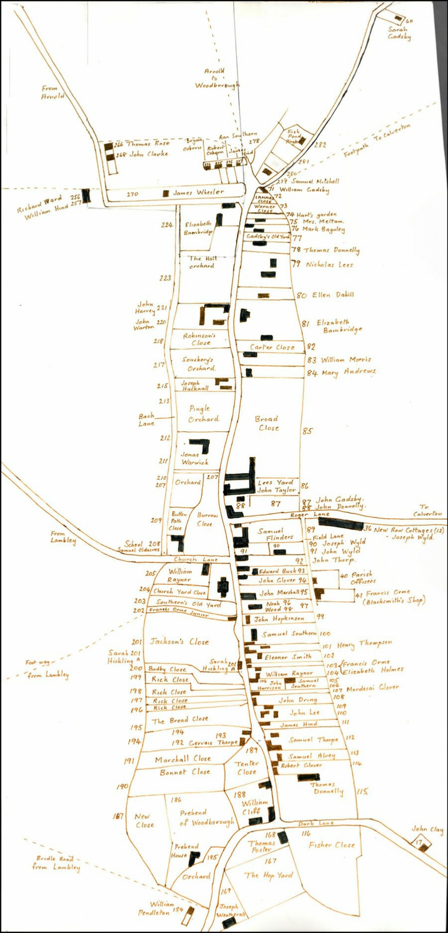
The plan above represents Woodborough village post Enclosure and was copied by an unknown person, it is considered an accurate portrayal of the village in 1798. Orientation is west (top) and east (bottom) with Woodborough Hall plot 224 occupied then by Miss Elizabeth Bainbrigge. Nether Hall plot 186 named as Prebendal House at the eastern end. The plan does not show outlying land or buildings. Outlying enclosed parish land also not included.
Note the distribution of buildings, the majority of which, being on the north side of Main Street (also known as Towne Street). The north side being slightly more elevated than land on the south side of Main Street, the south side plots being on a flood plain.
| Navigate this site |
| 001 Timeline |
| 100 - 114 St Swithuns Church - Index |
| 115 - 121 Churchyard & Cemetery - Index |
| 122 - 128 Methodist Church - Index |
| 129 - 131 Baptist Chapel - Index |
| 132 - 132.4 Institute - Index |
| 129 - A History of the Chapel |
| 130 - Baptist Chapel School (Lilly's School) |
| 131 - Baptist Chapel internment |
| 132 - The Institute from 1826 |
| 132.1 Institute Minutes |
| 132.2 Iinstitute Deeds 1895 |
| 132.3 Institute Deeds 1950 |
| 132.4 Institute letters and bills |
| 134 - 138 Woodborough Hall - Index |
| 139 - 142 The Manor House Index |
| 143 - Nether Hall |
| 139 - Middle Manor from 1066 |
| 140 - The Wood Family |
| 141 - Manor Farm & Stables |
| 142 - Robert Howett & Mundens Hall |
| 200 - Buckland by Peter Saunders |
| 201 - Buckland - Introduction & Obituary |
| 202 - Buckland Title & Preface |
| 203 - Buckland Chapter List & Summaries of Content |
| 224 - 19th Century Woodborough |
| 225 - Community Study 1967 |
| 226 - Community Study 1974 |
| 227 - Community Study 1990 |
| 400 - 402 Drains & Dykes - Index |
| 403 - 412 Flooding - Index |
| 413 - 420 Woodlands - Index |
| 421 - 437 Enclosure 1795 - Index |
| 440 - 451 Land Misc - Index |
| 400 - Introduction |
| 401 - Woodborough Dykes at Enclosure 1795 |
| 402 - A Study of Land Drainage & Farming Practices |
| People A to H 600+ |
| People L to W 629 |
| 640 - Sundry deaths |
| 650 - Bish Family |
| 651 - Ward Family |
| 652 - Alveys of Woodborough |
| 653 - Alvey marriages |
| 654 - Alvey Burials |
| 800 - Footpaths Introduction |
| 801 - Lapwing Trail |
| 802 - WI Trail |