

Woodborough’s Heritage
An ancient Sherwood Forest village, recorded in Domesday
In the western side the intervening ground between the inner fosse and outer vallum widens into a broad platform.
The position of this stronghold is the centre of many surrounding camps, and communication could easily be made with those at Lambley on the south; Lowdham and Thurgarton on the east; Epperstone and Oxton on the north; and the two in the parish of Arnold in the west.
Acknowledgement:
- Victoria County History – a History of Nottinghamshire.
____________________________________________________________________________________________________
Ancient woodlands surrounding Woodborough - Victoria County History
Fox Wood, Woodborough:
Seven miles north-east from Nottingham and half a mile south of Calverton is Fox Wood, in which is one of the most interesting earthworks of the county. It is a matter of regret that destructive forces have shorn it of its original size and plan. The swell of the ground gives a prominence to the site.
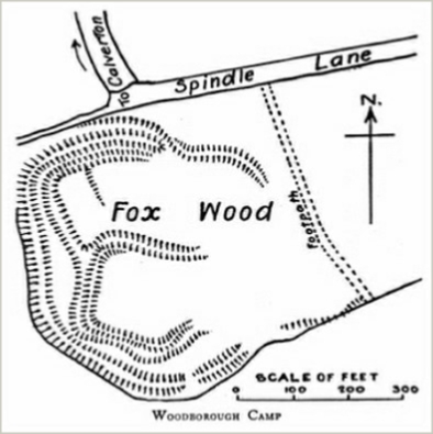
At present the remains are somewhat oval in form. The strongest position, approaching a square, has three sides of a vallum [a Roman rampart or earthwork] and fosse [a ditch or moat, especially one dug as a fortification]; but on the eastern side they begin to curve outwards into another court, which possibly provided a well-defended entrance into this innermost area. On the north is another court with the fosse remaining on the north and west sides; at the north-east the defence changes into a vallum which apparently, by the progress of its line, joined the northern entrenchments of the inner court; but the eastern side is lost.
From the middle of the northern side a strong vallum, embracing all the inner works, passes around the western and southern sides, at the extremity of which latter it is destroyed; this entrenchment is probably older than the interior works.
At the middle-north point is an entrance, difficult of access; the agger [a Roman word for an embankment or rampart] is here incurved, while another rampart, taking the same curve outwardly, forms a sunken approach, which for 180 ft even in its mutilated state could be covered by a cross-fire from both sides.
| Navigate this site |
| 001 Timeline |
| 100 - 114 St Swithuns Church - Index |
| 115 - 121 Churchyard & Cemetery - Index |
| 122 - 128 Methodist Church - Index |
| 129 - 131 Baptist Chapel - Index |
| 132 - 132.4 Institute - Index |
| 129 - A History of the Chapel |
| 130 - Baptist Chapel School (Lilly's School) |
| 131 - Baptist Chapel internment |
| 132 - The Institute from 1826 |
| 132.1 Institute Minutes |
| 132.2 Iinstitute Deeds 1895 |
| 132.3 Institute Deeds 1950 |
| 132.4 Institute letters and bills |
| 134 - 138 Woodborough Hall - Index |
| 139 - 142 The Manor House Index |
| 143 - Nether Hall |
| 139 - Middle Manor from 1066 |
| 140 - The Wood Family |
| 141 - Manor Farm & Stables |
| 142 - Robert Howett & Mundens Hall |
| 200 - Buckland by Peter Saunders |
| 201 - Buckland - Introduction & Obituary |
| 202 - Buckland Title & Preface |
| 203 - Buckland Chapter List & Summaries of Content |
| 224 - 19th Century Woodborough |
| 225 - Community Study 1967 |
| 226 - Community Study 1974 |
| 227 - Community Study 1990 |
| 400 - 402 Drains & Dykes - Index |
| 403 - 412 Flooding - Index |
| 413 - 420 Woodlands - Index |
| 421 - 437 Enclosure 1795 - Index |
| 440 - 451 Land Misc - Index |
| 400 - Introduction |
| 401 - Woodborough Dykes at Enclosure 1795 |
| 402 - A Study of Land Drainage & Farming Practices |
| People A to H 600+ |
| People L to W 629 |
| 640 - Sundry deaths |
| 650 - Bish Family |
| 651 - Ward Family |
| 652 - Alveys of Woodborough |
| 653 - Alvey marriages |
| 654 - Alvey Burials |
| 800 - Footpaths Introduction |
| 801 - Lapwing Trail |
| 802 - WI Trail |