

Woodborough’s Heritage
An ancient Sherwood Forest village, recorded in Domesday
Woodborough’s drains, dykes & flooding
Introduction: This is the first of nine articles covering various aspects of the Woodborough drains, dykes and flooding. Follow the sequence through to get the wider picture.
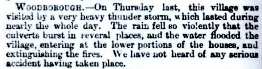
The following article appeared in the Nottinghamshire Guardian on Thursday 20th August 1857 so would be reporting on a weather event that happened the previous Thursday the 13th. It so happens that it is the earliest known flood of the village.
Top of this page a press cutting from the Nottinghamshire Guardian reporting on a flooding event that happened on 13th August 1857.
What is the evidence of past flooding? Well we now have a press cutting that confirms a severe flood in Woodborough in August 1857. Much later a photograph dated 1912 of Main Street in flood, they both confirm the fact that flooding in Woodborough is not confined to recent events.
There is photographic evidence and evidence in print back to 1912 and 1857 respectively see above; there are also the recollections of older residents who remember flooding in their lifetime. Before the two housing estates of Smalls Croft and Pinfold Close and Crescent were built, the meadows upon which they were built flooded mainly in winter leaving standing water for weeks or months. These meadows would act as a flood plain to the dykes. There are also references to flooding in the minutes of the Parish Council and entries in various past editions of the Woodborough Newsletter.
Acknowledgements:
- Introduction by John Hoyland 2007.
- Plan by Louise Ringer.
____________________________________________________________________________________________________
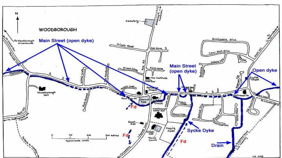
Continuous blue lines represent points where the dyke is open. Dashed lines are where it is underground. Fd indicates field drains.
It might be thought that Woodborough has a poor history of flooding. That is a matter of opinion, to those with property that has been flooded, once is too many. The village does lie in a shallow valley and there is a dyke that runs into the village from the west and exits to the east, it runs the length of Main Street for approximately 1 mile. The section along Main Street was originally described as Towne Dyke. This used to be an open dyke throughout its length and mostly follows the line of Main Street, that is, until housing estates were built in the 1970’s. Some stretches of the dyke are now open and some covered. Other reasons for covering sections of the Main Street dyke would have been to enable the roadway to be widened and pavements added. There are other drains that feed into the Main Street dyke which also has to cope with surface water drainage.
| Navigate this site |
| 001 Timeline |
| 100 - 114 St Swithuns Church - Index |
| 115 - 121 Churchyard & Cemetery - Index |
| 122 - 128 Methodist Church - Index |
| 129 - 131 Baptist Chapel - Index |
| 132 - 132.4 Institute - Index |
| 129 - A History of the Chapel |
| 130 - Baptist Chapel School (Lilly's School) |
| 131 - Baptist Chapel internment |
| 132 - The Institute from 1826 |
| 132.1 Institute Minutes |
| 132.2 Iinstitute Deeds 1895 |
| 132.3 Institute Deeds 1950 |
| 132.4 Institute letters and bills |
| 134 - 138 Woodborough Hall - Index |
| 139 - 142 The Manor House Index |
| 143 - Nether Hall |
| 139 - Middle Manor from 1066 |
| 140 - The Wood Family |
| 141 - Manor Farm & Stables |
| 142 - Robert Howett & Mundens Hall |
| 200 - Buckland by Peter Saunders |
| 201 - Buckland - Introduction & Obituary |
| 202 - Buckland Title & Preface |
| 203 - Buckland Chapter List & Summaries of Content |
| 224 - 19th Century Woodborough |
| 225 - Community Study 1967 |
| 226 - Community Study 1974 |
| 227 - Community Study 1990 |
| 400 - 402 Drains & Dykes - Index |
| 403 - 412 Flooding - Index |
| 413 - 420 Woodlands - Index |
| 421 - 437 Enclosure 1795 - Index |
| 440 - 451 Land Misc - Index |
| 400 - Introduction |
| 401 - Woodborough Dykes at Enclosure 1795 |
| 402 - A Study of Land Drainage & Farming Practices |
| People A to H 600+ |
| People L to W 629 |
| 640 - Sundry deaths |
| 650 - Bish Family |
| 651 - Ward Family |
| 652 - Alveys of Woodborough |
| 653 - Alvey marriages |
| 654 - Alvey Burials |
| 800 - Footpaths Introduction |
| 801 - Lapwing Trail |
| 802 - WI Trail |