

Woodborough’s Heritage
Woodborough, a Sherwood Forest Village, recorded in Domesday
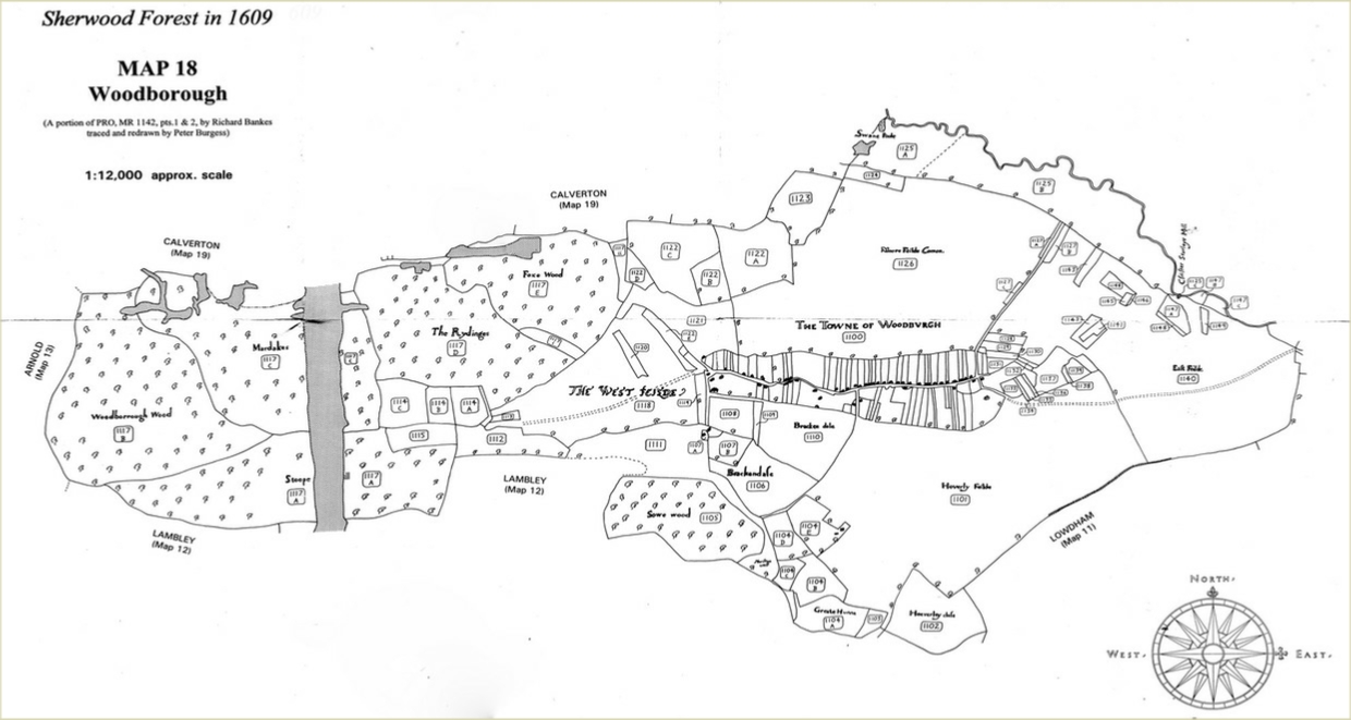
Woodborough in 1609
Landowners and tenants in Woodborough recorded by Richard Banks, a surveyor born in Coventry, in his Crown Survey map of Sherwood Forest 1609, of which the Woodborough Parish makes up just one small piece.
The following is given with acknowledgement and thanks to The Thoroton Society Record Series 1997, Sherwood Forest in 1609. This map depicts the whole Parish of Woodborough. From the plot list below, the first column gives only brief information of the plot number and the freeholder’s name, then a more detailed description and the last column provides the acreage.
Stephanos Mastoris records there is text that accompanies the map and it is the earliest map of the forest. In the text every acre, rood, and perch is analysed as belonging to each Freeholder. The cartographer was Richard Banks and the map was completed in 1609. The survey was undertaken between March 1607 and February 1608. It was part of an ongoing process by Queen Elizabeth I and King James I to examine land tenure to see if the Crown had any rights over it. Between 1600 and 1624 they engaged in a policy of tracing ‘concealed’ land and appropriating it. This was land to which the Freeholder could not prove ownership or land which had been assarted illegally. Heavy rents were then charged on such land. The costs of the survey were more than covered by the increased revenue from fines that it generated. No doubt neighbouring landlords were intimidated into having their estates mapped by way of self protection.
____________________________________________________________________________________________________
The extent of woodland shown in Woodborough in 1609 - The main area of woodland in the village was to the west of the West Field and belonged to Strelley of the Upper Hall. At the time it included Woodborough Wood, Stoup Hill Coppice, Mardales, Fox Wood and the Riddings. The latter appears to have been woodland which had been felled and would have been called a ‘waste’ at the time. The large area of woodland and coppice covered about 530 acres. The other area was on the south side of Bank Hill and reached as far as Agram Wells on Lingwood Lane. It was by Mr John Wood of the Middle Hall (the present Manor). It included Sowe Wood or Sowoode and Stanley Wood, which was the coppice and was about 56 acres in extent.
It appears that these two areas of woodland, totalling about 586 acres, remained for about three centuries until the time of the Inclosure Award in 1798, although by then all of the woodland was being coppiced.
|
Plot number & name of freeholder |
A brief description of the land as published by Thoroton |
Acreage |
|
1100 Woodborough |
The whole town and closes, not cast up in the plot |
99a.2r.27p |
|
1101 Common to Woodborough |
Great arable field next adjoining and also belonging to the said town, called Hoverley Field |
231a.2r.38p |
|
1102 Bishop of York |
One arable close lying unto the said field, called Hoverley Close, in the occupation of Christopher Foster, tenant, the Bishop of Yorke, freeholder |
28a.2r.21p |
|
1103 Christopher Turner |
One parcel of wood next thereunto adjoining, in the occupation of Christopher Turner, freeholder |
2a.3r.5p |
|
|
Ad huc Woodborrough [Woodborough] Lordship |
|
|
1104 John Wood |
One other parcel of wood ground next thereunto adjoining, called Greate Hunna Wood and four closes of pasture and arable near unto the said wood adjoining, in the occupation of John Wood, freeholder |
40a.2r.38p |
|
1105 John Wood |
One other wood next to the same adjoining called Sowe Wood, John Wood, freeholder |
51a.3r.16p |
|
1106 John Wood |
One other close next thereunto adjoining, called Blackenclose {note: Brackenclose], in the occupation of John Wood, freeholder |
21a.0r.4p |
|
1107 John Wood |
Two cots and one close near adjoining, called Mr Woodes Coppice [note: John Wood], freeholder |
5a.2r.0p |
|
1108 Mr Strelley |
One other close next adjoining, in the occupation of Mr Sturley, freeholder [note: Sturley crossed out] |
8a.0r.24p |
|
1109 Leyes |
One other close next thereunto adjoining, in the occupation of Leyes, freeholder |
1a.2r.21p |
|
1110 Common to Woodborough |
One other close next thereunto adjoining, being part of the West Feild [1118] called Blackendale [note: Brackedale] |
36a.1r.18p |
|
1111 |
One piece of waste ground lying between Sowe Wood [1105] & West Feild [1118] [note: depicts 'Merston Well' at south-east of the close] |
37a.0r.20p |
|
1112 John Wood |
One close next adjoining to the said waste, in the occupation of Mr John Wood [note: Woods crossed out] |
16a.2r.17p |
|
1113 John Crofts of Oxton |
One other close near adjoining to the same, in the occupation of John Croftes, freeholder [note: John Crofts of Oxton in a list of freeholders here in 1612] |
1a.0r.32p |
|
1114 Christopher Strelley |
Three other closes mear thereunto adjoining, in the occupation of Christopher Strelley, freeholder [note: Sturley crossed out, Christopher Strelley's pedigree is given in Visitations 1662/1663 Thoroton pages 73-76] |
25a.2r.7p |
|
1115 Prebend of Southwell |
One other close next thereunto adjoining, in the occupation of the Prebend of Southwell, Christopher Fauster [Foster], tennent |
7a.3r.28p |
|
1116 Prebend of Southwell |
One wood called Foxwood, in the occupation of Christopher Fauster [Foster], the Prebend of Southwell, freeholder [note: this entry is a later insertion in the same hand as the main text, entry not found] |
371a.1r.0p |
|
1117 Christopher [Strelley] |
Five woods near about the same adjoining, called by the several names of Stoope Hill, Woodborough Wood, Mardales [and] Ridling in the occupation of Christopher Sturley, freeholder |
445a.0r.0p |
|
1118 Common to Woodborough |
One common arable field next thereupto adjoining and to the town of Woodborough belonging, called West Feild [see also 1110] called West Field [note: 'Sutt' crossed out] |
77a.2r.12p |
|
1119 |
One other close lying upon said field [1118], in the occupation of [-] |
1a.2r.3p |
|
1120 John Craftes |
One other close adjoining upon the said field [1118], in the occupation of John Craftes, freeholder [note: John Chaddock, tennant] |
2a.1r.32p |
|
1121 |
One other close near adjoining and being part of West Feild [1118] |
22a.0r.31p |
|
|
Ad huc Woodborrough [Woodborough] Lordship |
|
|
1122 Christopher Sturley |
Five other closes about the same adjoining in the occupation of Mr Christopher Sturley, freeholder [note: 'Christopher Clarke, tennant] |
63.a.3r.25p |
|
1123 Southwell Church |
One other close next thereunto adjoining, in the occuptaion of Christopher Foster, tenant, tenant, the Church of Southwell, freeholder |
18a.0r.39p |
|
1124 John Wood |
One other close near thereunto adjoining, in the occupation of John Wood, freeholder [note: William Oldney, tenant] |
4a.3r.35p |
|
1125 |
One other long parcel of ground lying upon the bound of the Forest, extending from Swanne Poole to Christopher Sturley's mill [1125c]. [note: This mill is depicted but not named on the Belvoir map of Sherwood Forest of c.1600] |
107.a2r.9p |
|
1126 Common to Woodborough |
One common field next thereunto adjoining and belonging to Woodborough, called Moore Feild Common |
222a1r.7p |
|
1127 Christopher Foster |
Two (three) other little closes lying on 1126 [notes: 1127 A 0a.3r.11p Christiopher Foster, 1127B 1a.1r.15p William Foster, lord, 1127C 0a.2r.5p] |
2a.2r.29p |
|
1128 Nicholas Leyes (Lees?) |
One other close lying near said town [Woodborough], in the occupation of Nicholas Leyes, freeholder |
1a.2r.0p |
|
1129 Thomas Alvey |
One other close next thereunto adjoining, in the occupation of Thomas Alvey, freeholder |
1a.3r.18p |
|
1130 Thomas Wyer |
One other close next thereunto adjoining, in the occupation of Thomas Wyre, freeholder |
1a.0r.28p |
|
1131 Richard Alvey |
One other close next thereunto adjoining, in the occupation of Richard Alvey, freeholder |
1a.1r.27p |
|
1132 Henry Alvey |
One other close next thereunto adjoining, in the occupation of Henry Alvey, freeholder |
0a,1r.11p |
|
1133 |
One other close near thereunto adjoining, icalled Ould Meade, in the occupation of [-] |
1a.1r.29p |
|
1134 Nicholas Leyes |
One other close next thereunto adjoining, in the occupation of Nicholas Leyes, freeholder |
0a,1r.10p |
|
1135 Thomas Alvey |
One other close next thereunto adjoining, in the occupation of Thomas Alvey, freeholder |
0a. 3r.0p |
|
1136 Thomas Wyer |
One other close next thereunto adjoining, in the occupation of Thomas Wyre, freeholder |
? |
|
1137 Christopher Strelley |
One other close next thereunto adjoining, in the occupation of Christopher Sturley, freeholder |
6a.2r.21p |
|
1138 Nicholas Leyes |
One other little close next thereunto adjoining, in the occupation of Nicholas Leyes |
0a.1r.0p |
|
1139 Southwell Church |
One other close next thereunto adjoining, in the occupation of Southwell Church, freeholder |
1a.3r.10p |
|
1140 Common to Woodborough |
One common arable field next thereunto adjoining and belonging to the said town of Woodborough,called East Feild |
? |
|
|
Ad huc Woodborrough [Woodborough] Lordship |
|
|
1141 Mr Strelley |
One other close lying in East Feild [note: 1140], in the occupation of Mr Sturley, freeholder |
1a.0r.14p |
|
1142 Southwell Church |
One other close next adjoining to the same, in the occupation of Southwell Church, freeholder |
2a.1r.30p |
|
1143 John Alvey |
One other close lying upon the said field [note: 1140] East Feild, in the occupation of John Alvey |
1a.3r.12p |
|
1144 Christopher Strelley |
One other close near thereunto adjoining, in the occupation of Christopher Sturley, freeholder |
1a.3r.30p |
|
1145 Southwell Church |
One other little close next thereunto adjoining, in the occupation of Southwell Church , freeholder |
0a.1r.36p |
|
1146 Nicholas Leyes |
One other little close next thereunto adjoining, in the occupation of Nicholsa Leyses, freeholder |
0a.0r.36p |
|
1147 Christopher Strelley |
Three other closes lying near unto the same, in the occupation of Christopher Leyes, freeholder |
4a.3r.27p |
|
1148 William Foster |
One other close near thereunto adjoining, in the occupation of William Foster, freeholder |
0a.3r.22p |
|
1149 Nicholas Jebes |
One other close near thereunto adjoining, in the occupation of Nicholas Jebes [note: Jebes or Jeves] |
0a.3r.33p |
|
|
|
|
|
|
|
|
|
|
FINIS WOODBORROUGH LORDSHIP |
|
Acknowledgement:
- We are grateful to the Thoroton Society for allowing the use of the 1609 map of Sherwood Forest and also the plot descriptions both of which were published in their book ‘Sherwood Forest in 1609’ - A Crown survey by Richard Bankes. The original survey by Bankes was transcribed and edited by Stephanos Mastoris and Sue Groves. Thoroton Society Record Series Volume XL (1997).
Since Inclosure most of the woodland has disappeared, due probably to the increased use of brick for building purposes starting in the village in the early 18th century, and to the demand for agricultural produce due to the Industrial Revolution and the population growth of Nottingham in the early 19th century. By the beginning of the 20th century, with hand framework knitting in rapid decline, the village was mainly agricultural – farming and market gardening – and little woodland was left. Today (1990) probably less than ten acres of poor woodland remain within the parish boundary. This would include an area within the parish boundary between Bank Hill, Nottingham Road, Dorket Head, Georges Lane and Spindle Lane
SHERWOOD FOREST IN 1609
A Crown Survey by Richard Bankes
published by The Thoroton Society
Woodborough Lordship
All of this lordship (the whole of Woodborough parish is shown on a portion of the map drawn to accompany this survey).
Woodborough is located on the Belvoir map of Sherwood Forest of c. 1600. brief account of the manorial history of this lordship is given
in Thoroton 1677 pages 31 to 35. Read the modern interpretation to do so follow this link: [Thoroton 1677]
Note: For details of the watermills on the Doverbeck in this lordship and beyond use this link: [Woodborough watermill].
Below: The Woodborough section of Richard Bankes 1609 map of Sherwood Forest shows that the Parish is largely wooded in the west and south. It also illustrates the pre enclosure larger fields. Ploughman Wood to the south-east is not shown on this map, it is included in the neighbouring Parish of Lowdham’s version of the 1609 map.
____________________________________________________________________________________________________________________________
| Navigate this site |
| 001 Timeline |
| 100 - 114 St Swithuns Church - Index |
| 115 - 121 Churchyard & Cemetery - Index |
| 122 - 128 Methodist Church - Index |
| 129 - 131 Baptist Chapel - Index |
| 132 - 132.4 Institute - Index |
| 129 - A History of the Chapel |
| 130 - Baptist Chapel School (Lilly's School) |
| 131 - Baptist Chapel internment |
| 132 - The Institute from 1826 |
| 132.1 Institute Minutes |
| 132.2 Iinstitute Deeds 1895 |
| 132.3 Institute Deeds 1950 |
| 132.4 Institute letters and bills |
| 134 - 138 Woodborough Hall - Index |
| 139 - 142 The Manor House Index |
| 143 - Nether Hall |
| 139 - Middle Manor from 1066 |
| 140 - The Wood Family |
| 141 - Manor Farm & Stables |
| 142 - Robert Howett & Mundens Hall |
| 200 - Buckland by Peter Saunders |
| 201 - Buckland - Introduction & Obituary |
| 202 - Buckland Title & Preface |
| 203 - Buckland Chapter List & Summaries of Content |
| 224 - 19th Century Woodborough |
| 225 - Community Study 1967 |
| 226 - Community Study 1974 |
| 227 - Community Study 1990 |
| 400 - 402 Drains & Dykes - Index |
| 403 - 412 Flooding - Index |
| 413 - 420 Woodlands - Index |
| 421 - 437 Enclosure 1795 - Index |
| 440 - 451 Land Misc - Index |
| 400 - Introduction |
| 401 - Woodborough Dykes at Enclosure 1795 |
| 402 - A Study of Land Drainage & Farming Practices |
| People A to H 600+ |
| People L to W 629 |
| 640 - Sundry deaths |
| 650 - Bish Family |
| 651 - Ward Family |
| 652 - Alveys of Woodborough |
| 653 - Alvey marriages |
| 654 - Alvey Burials |
| 800 - Footpaths Introduction |
| 801 - Lapwing Trail |
| 802 - WI Trail |