

Woodborough’s Heritage
Woodborough, a Sherwood Forest Village, recorded in Domesday
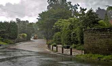
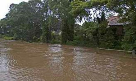
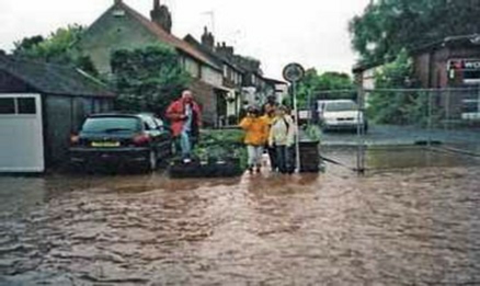
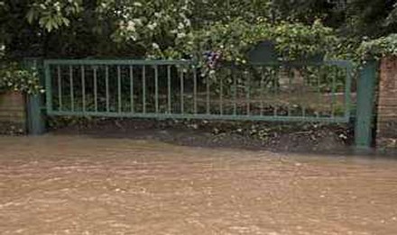
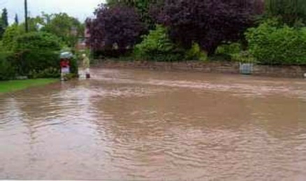
Woodborough Flooding - Summer 2007
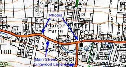
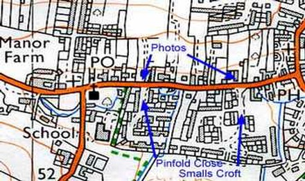
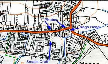
These photographic sequences have all been kindly provided by Woodborough residents and acknowledgement to them is shown at the foot of each page. These pages of photographs represent a small selection from a total of around 200 photographs. Both used and unused photographs will be retained for archival purposes. These sequences of photograph start at the west end of Main Street and progress along to the eastern end, a distance of about one mile.
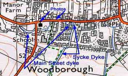
Acknowledgement is made to: O.S. Pathfinder map 813 for extracts.
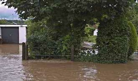
Westfields towards Foxwood Lane and Main Street:
-D.Robso.jpg)
-D.Robso.jpg)
-W.Halla.jpg)
-D.Robso.jpg)
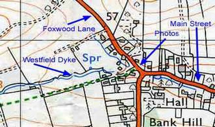
03: Westfields towards Main St junction and Bank Hill 04: On Foxwood Lane looking back towards Westfields
Acknowledgements:
- Photos: 01 02 03 D Robson
- 04 W Hallam
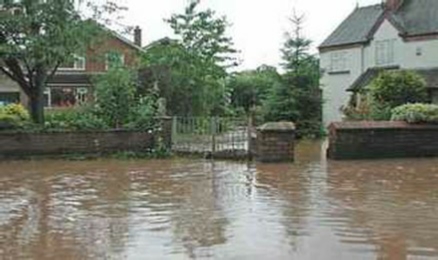
Main Street from Bank Hill to The Meadows - Second sequence
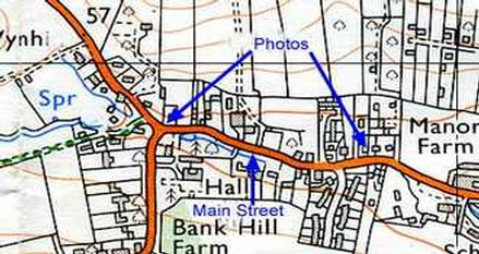
03: Main Street near Hall Farm looking west 04: View east towards The Meadows
Acknowledgements:
- Photos: 01 02 A Kowal
- 03 P Wood
- 04 D Rose
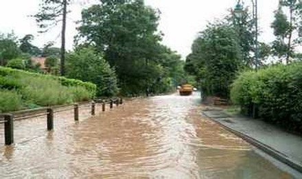
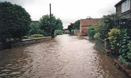
The Meadows to St Swithun's Church - Third sequence
P.Wood.jpg)
JH.jpg)
01: Main Street looking west towards The Meadows 02: From the former racing stable looking west
03: Former racing stables towards Governors' Field 04: Outside the Four Bells towards St Swithun’s Church
JH.jpg)
A.Bradley.jpg)
D.Rose.jpg)
JH.jpg)
05: From corner of Lingwood Lane looking west 06: From corner of Lingwood Lane looking east
07: From Main Street looking up Lingwood Lane 08: From Roe Hill towards Main Street
JH.jpg)
G.Humber.jpg)
Acknowledgements:
- Photos: 01 P Wood
- 02 03 06 07 J Hoyland
- 04 D Rose
- 05 A Bradley
- 08 G Humber
St Swithun's Church to Pinfold Close - Fourth sequence
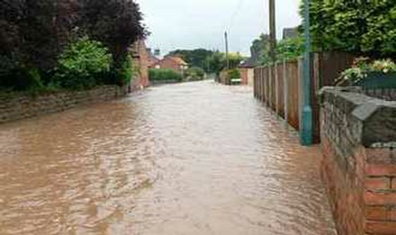
01: Main Street from the Pinfold 02: Church View cottages & the Co-op stores
03: The dyke to the right of the Old Co-op 04: Main Street viewed from Pinfold Close
Acknowledgements:
- Photos: 01 R Hanson
- 02 G Humber
- 03 A Kowal
- 04 R Drury
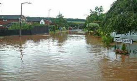
Pinfold Close to Smalls Croft - Fifth sequence
01: The dykes flows away from Main Street at 122 02: The dyke returns towards Main Street at 124
03: A view west towards Pinfold Close 04: A view west towards the Post Office
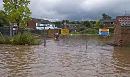
05: A building site under water opposite the Post Office 06: Main Street towards Smalls Croft
07: A view of the Post Office from across a building site 08: Smalls Croft from Main Street
Acknowledgements:
- Photos: 01 G Humber
- 03 & 05 A Kowal
- 02 J Hoyland
- 04 & 08 P Wood
- 06 D Burgess
- 07 M Kirk
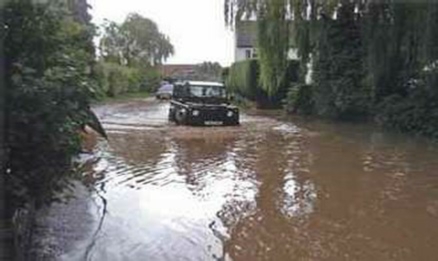
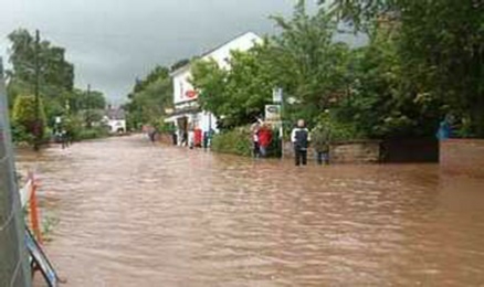
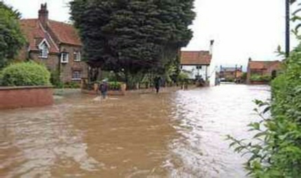
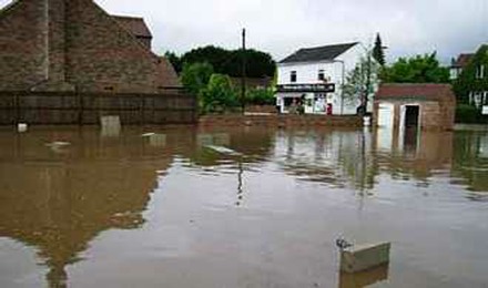
Smalls Croft to Nags Head - Sixth sequence
P.Wood.jpg)
A.Kowal.jpg)
01: On Westfields at the point of where the dyke overflows 02: On Westfields near the junction with Foxwood Lane
01: Main Street from near Bank Hill 02: Main Street near Hall Farm House
01: Main Street manhole forced up 02: Inspection grate on Main Street outside Middups
03: A barrier in use at 158 Main Street 04: Main Street looking east towards Nags Head
R.Hanson.jpg)
P.Wood.jpg)
05: A grate by Middups, attempts being made to unblocked it. 06: A shared driveway at 162 Main Street, the only place where flood water can flow away and back to the dyke
07: The extent of flood water on Main Street near the bus stop 08: Outside the Nags Head on Main Street at its
junction with Shelt Hill & Lowdham Lane
P.Wood.jpg)
P.Wood.jpg)
M.Smith.jpg)
P.Wood.jpg)
Acknowledgements:
- Photos: 01 03 05 06 & 08 P Wood
- 02 R Hanson
- 04 A Kowal
- 07 M Smith
____________________________________________________________________________________________________
| Navigate this site |
| 001 Timeline |
| 100 - 114 St Swithuns Church - Index |
| 115 - 121 Churchyard & Cemetery - Index |
| 122 - 128 Methodist Church - Index |
| 129 - 131 Baptist Chapel - Index |
| 132 - 132.4 Institute - Index |
| 129 - A History of the Chapel |
| 130 - Baptist Chapel School (Lilly's School) |
| 131 - Baptist Chapel internment |
| 132 - The Institute from 1826 |
| 132.1 Institute Minutes |
| 132.2 Iinstitute Deeds 1895 |
| 132.3 Institute Deeds 1950 |
| 132.4 Institute letters and bills |
| 134 - 138 Woodborough Hall - Index |
| 139 - 142 The Manor House Index |
| 143 - Nether Hall |
| 139 - Middle Manor from 1066 |
| 140 - The Wood Family |
| 141 - Manor Farm & Stables |
| 142 - Robert Howett & Mundens Hall |
| 200 - Buckland by Peter Saunders |
| 201 - Buckland - Introduction & Obituary |
| 202 - Buckland Title & Preface |
| 203 - Buckland Chapter List & Summaries of Content |
| 224 - 19th Century Woodborough |
| 225 - Community Study 1967 |
| 226 - Community Study 1974 |
| 227 - Community Study 1990 |
| 400 - 402 Drains & Dykes - Index |
| 403 - 412 Flooding - Index |
| 413 - 420 Woodlands - Index |
| 421 - 437 Enclosure 1795 - Index |
| 440 - 451 Land Misc - Index |
| 400 - Introduction |
| 401 - Woodborough Dykes at Enclosure 1795 |
| 402 - A Study of Land Drainage & Farming Practices |
| People A to H 600+ |
| People L to W 629 |
| 640 - Sundry deaths |
| 650 - Bish Family |
| 651 - Ward Family |
| 652 - Alveys of Woodborough |
| 653 - Alvey marriages |
| 654 - Alvey Burials |
| 800 - Footpaths Introduction |
| 801 - Lapwing Trail |
| 802 - WI Trail |