

Woodborough’s Heritage
Woodborough, a Sherwood Forest Village, recorded in Domesday
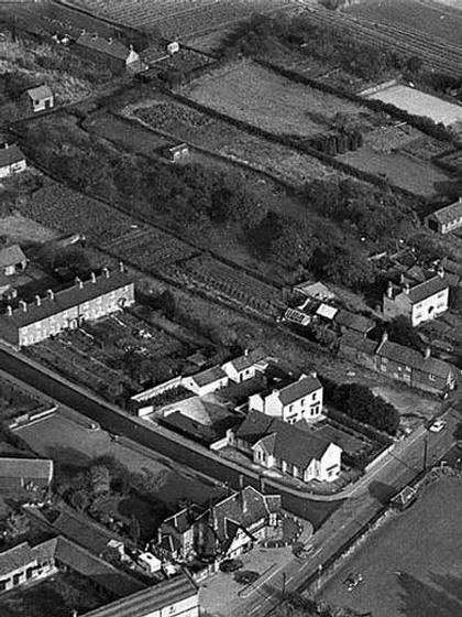
The end of the Field Lane plots can be identified, at the top left side of this photograph there is a small square structure and a row of cottages, the plots were between these buildings.
This plan, taken from the 1876 sale details, shows the exact position of the Field Lane allotments, shown here as ‘Woodborough Poor’. The two buildings shown towards the bottom of the plot have at some time been demolished.
“Crook Dole Lane
One other private Horse Carriage and Drift Road along an Ancient Lane called CROOK DOLE LANE to an old Inclosure belonging to Samuel HEYWOOD and from thence over the said Samuel Heywoods Close to a Close belonging to Elizabeth TOTTIE called NETHER CLOSE for the use of the several Owners and Occupiers of Lands adjoining to or abutting upon the said Road. One other private Horse Carriage and Drift Road from the Town of Calverton.
Drains
And we the said Commissioners having caused a Ditch or Drain to be made from the Parish of Woodborough through GRIMESMOOR COMMON and through part of a Close and adjoining thereto belonging to Elizabeth BAINBRIGGE called CRINGLE BECKS CLOSE and from thence branching into two distinct drains one of them going between certain Closes called GRIMESMOOR LANE CLOSES on the Southward Side thereof. And the NETHER CLOSES, GRAVES CLOSE and the SNICKLEBRIDGE CLOSES on the Northward Side thereof to a Close belonging to Nathaniel SIMPSON called BURNOR CLOSE and the other Branch going through other part of the said CRINGLE BECKS CLOSE and through the NETHER CLOSES, the INTAKES and the MOOR CLOSES belonging to Elizabeth TOTTIE, Samuel HEYWOOD, William CLAY, Henry HOLLINS, Thomas METTAM, William WYLD, Thomas SMITH, John HOPKINS, Abel SMITH, as Trustee as aforesaid, George HALLAM and Thomas COOPER, James BINGHAM, also- Samuel MORLEY, Elizabeth MORLEY, William REDGATE the Younger, John NEWTON, Charles HALLAM, Humphrey HOLLINS, Francis READ, Mary BAINBRIGGE and William BUTTERY and Elizabeth BAINBRIGGE to a Close belonging to the said Abel SMITH in his own right called THORNDALE CLOSE”.
The Woodborough Allotments - Revised October 2022
At the time of Woodborough’s Inclosure in 1795 there were three designated areas of allotments in the parish, Foxwood, Town Lands and Poor Land. Later there were plots off Shelt Hill and Lowdham Lane. The history of the allotments is linked closely with the Charities described elsewhere in this website.
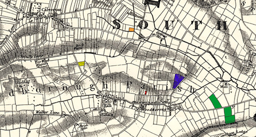
The Cassini map below dated 1835 below identifies all the various allotments. From left to right - coloured yellow Foxwood on east side of Foxwood Lane. Coloured light brown Nether Close [Poor Lands] in the parish of Calverton has been identified as being at the end of Crook Dole Lane and north of Moor Lane. Coloured red - Town Lands for Woodborough Poor, a small plot on the north side of Field Lane. Coloured blue - three plots on the north-west side of Shelt Hill ownership unknown. Coloured green - New Lands on the north side of Lowdham Lane and Hawley Hill next to Club Houses on the south side both belonged to the Woodborough Male Friendly Society. A plot of 4 acres on Roe Hill has not been identified.
Foxwood Allotment Gardens
This land, consisting of 2.29 acres, was left to the Woodborough Parish to satisfy a need for allotments; the description reads "a piece or parcel of land lying in a place called Foxwood (no. 57 on the field map, the 1795 Enclosure Map) containing 2 acres, 1 rood and 20 perches, an area today of 2.377 acres, bounded on the north by land awarded to William Denman, on or towards the east by a Close called Bonor or Bonner belonging to Elizabeth Bainbridge, on or towards the south by lands awarded to John Worton, and on or towards the west by the public carriage road leading to Calverton now known as Foxwood Lane. The fences, for inclosing such pieces of land against the roadway and against the land of John Worton, were to be made and thereafter maintained by the parish officers or owners or occupiers thereof".
.JPG)
.JPG)
Two photographs of the Foxwood allotments taken in 2001.
Left: Shows views over towards Bank Hill and right: looking east from the entrance gateway.
Town Lands (Woodborough Poor)
There were two plots of land close to the centre of Woodborough Village both to the north off Field Lane, which itself is off Roe Hill. This land, now built upon, is described as follows – one small piece of inclosed land belonging to Eleanor Smith (no.38 on the Enclosure map) consisting of 14 perches, the other small piece of inclosed land belonging to Elizabeth Bainbridge (no.39 on the Enclosure map) also of 14 perches. Also shown on this sale plan as Woodborough Poor. The total size of the land was 1,660 square yards. The Town Lands were sold to a builder in 1968 for £1578. 14s. 10d.
.jpg)
Poor’s Land (Nether Closes) - 1599
This land has been difficult to identify, but now The Calverton Preservation Society has located the area known as the Nether Closes from their copy of the Calverton Enclosure map dated 1720. The following description also provided by Calverton Pres and should be used in conjunction with the small segment of their map shown below. From this we have identified the plot coloured orange. The end of Crook Dole Lane, which runs through to Calverton Village, is shown top left with double dotted lines and Bonner Lane (grey) bottom left. The three dark solid lines represent dykes, two of which border the plot. Interestingly this plot can still be seen from aerial photographs of the location on Google Earth. The plot is identified coloured orange and the area measures just under 1½ acres which is very close to the measurement given for this piece as 1 acre 1 rood and 13 perches.
Two views of the Foxwood allotments taken in 1950
Left: Looking towards the top with Foxwood Lane on the left. Right: views over towards Bank Hill.
The Woodborough Newsletter reported in July 1965: It has been decided that it would be in the best interest of the Charity to recommend sale of part of the Foxwood Gardens land, and the procedure laid down by the Charity Commissioners is being put in hand. December 1967 a valuation of the Foxwood Garden allotments has been obtained to help the charity trustees and the Council in deciding whether the best use is being made. The matter is still under consideration. This land was left to the village in 1798 and is a registered charity; no decision can therefore be taken without the approval of the village and the consent of the charity commissioners. An opportunity in September 1968 has been taken to include on the agenda of the Parish Council the proposed sale of Foxwood Gardens land which the charity Trustees are recommending should be disposed of by public auction. However, at the Parish Council meeting a recommendation of the Trustees to sell the Foxwood Gardens was not accepted. It was felt that whilst there is a demand for allotments the land should be retained.
November 1969: It is hoped that the response will be sufficient to use the restored land to the fullest extent, but in the event of there being insufficient demand for allotments; the Council may have to decide an alternative use in order not to allow the land to deteriorate to its former state. For this reason applications should be received not later than 31st January 1970.
Foxwood Gardens. It is the Councils intention to restore this land at an early date and to allocate suitable areas for garden use from the 26th March 1970, at a reasonable rent. Parishioners who have not already asked for their names to be placed on the allotment list are invited to apply to the Clerk, who will keep them in touch with the position.
The spirit of the Foxwood allotments continues into the twenty-first century with all the allotments being fully let, generally to local residents. The latest known statements of distribution to the poor at Christmas, records show there were 47 recipients each receiving £15 in 1999, 45 receiving £15 in 2000 and 44 receiving £15 in 2001.
.JPG)
.JPG)
.jpg)
There is a field, situate in the parish of Calverton called the Nether Close, containing 1 acre. 1 rood. 13 perch, which was (as we are informed) awarded on the inclosure of the open fields of that parish to the poor of the parish of Woodborough, but we have not seen any document relating to it.
This field has been let for many years at the rent of 30s [shillings] per annum, to a family of the name of Baguley. It is now occupied by Samuel Baguley, and the rent has been of late years applied to the general purposes of the poor-rate.
We are informed that Mrs [Miss] Bainbridge, who has an estate in this parish received the rent until the time of her death, about 30 years ago [1797], and was accustomed to apply it towards the putting out of apprentices.
It seems proper that the field which is stated to be worth 50s per annum, should be let for its fair value, and (as far as can be judged from its former application), that the rent should be applied for the apprenticing of poor children of the parish.
Woodborough Allotments
A letter from Rev’d W E Buckland to the Parochial Electors of Woodborough
ALLOTMENT
As I am informed that it is constantly stated that Mr EDWARD ROBINSON and myself are opposed to Allotments for Working Men, I wish distinctly to contradict the statement. I am very much in favour of Allotments, and proposed the Resolution, which was carried unanimously by the Parish Council on January 6th 1895, that a Committee should be appointed to ascertain the names of applicants with other particulars, and I also voted for a resolution to obtain land by compulsion if it could not be got by voluntary agreement. But because I was in favour of proceeding with moderation and caution I was not re-elected on the Committee; and a one-sided Committee, no longer representing the whole parish, was appointed, which has grossly miss-managed the whole matter and brought forward resolutions which I could not support by my vote, though I did not vote against them.
I am convinced that if the present aggressive majority is re-elected no more land will be obtained except by compulsion; and it is most probable that the County Council will proceed with very great caution and only grant a compulsory order for a limited amount. It will then be found that compulsion will have done great harm to the cause, and it will be more difficult than ever to obtain more land. On the other hand if the electors return a majority of Moderate Men who can be trusted by owners and applicants to act with fairness, more land may be got voluntarily than by compulsion; and if that land is worked successfully there will be no difficulty in getting more afterwards.
My first effort will be to obtain land close at hand to be divided into small Allotments of roods, half-acres, and acres, which a working man can cultivate in his spare time for his home wants. But I should also be prepared to obtain land for small holdings of three or four acres on which a man would have to spend all his time for the supply of the market.
For thirteen years I had the supervision of sixty field allotments in my former parish so that I am well acquainted with the difficulties of collecting small rents to make up the rent due to the landlord, and of ensuring the proper cultivation of the whole. Yet those allotments were of very great use to working men, and my past experience has helped me to form opinions favourable to allotments, for the reasonable extension of which I am now ready to do my best.
Walter E. Buckland
March 21st., 1896
____________________________________________________________________________________________________
In those days Woodborough like all parishes of the time had to meet their share of a Poor Law Institution and the land was sold in 1849 to raise the special call made upon the parish for building the Basford Union Workhouse.
The allotments of Woodborough were a source of income for the Woodborough Charities; they are administered by the Woodborough Parish Council, distribution of funds being 'for the poor of Woodborough at Christmas'. Nowadays recipients are generally senior citizens, possibly living alone and without private pension or employment.
Other allotments not linked to the Charities of Woodborough
There were at least three other allotment gardens in the vicinity of Woodborough (shaded green on the map at the top of this page), two plots on Lowdham Lane near Club Houses, one on the north side of Lowdham Lane known as New Lands, the other to the south named Hawley Hill, both are attributed to the Woodborough Male Friendly Society as is one plot of four acres on Roe Hill, these are all recorded on the o.s. map of 1899. (See the article about the Male Friendly Society).
Other allotment gardens (coloured blue) are also shown on the 1899 map recording them on the north-west side of Shelt Hill between the New Inn and Shelt Hill Farm. The plots are known to have belonged to Woodborough Parish Council but when this ownership commenced or ceased is not known.
See also Woodborough Parish Council page 510
Acknowledgements:
- Les Morgan former Woodborough Parish Council councillor
- Text by John Hoyland & Les Law
- Woodborough Parish Council Minutes October 2007
- Various back copies of Woodborough Newsletter
- Calverton Preservation Society
____________________________________________________________________________________________________
| Navigate this site |
| 001 Timeline |
| 100 - 114 St Swithuns Church - Index |
| 115 - 121 Churchyard & Cemetery - Index |
| 122 - 128 Methodist Church - Index |
| 129 - 131 Baptist Chapel - Index |
| 132 - 132.4 Institute - Index |
| 129 - A History of the Chapel |
| 130 - Baptist Chapel School (Lilly's School) |
| 131 - Baptist Chapel internment |
| 132 - The Institute from 1826 |
| 132.1 Institute Minutes |
| 132.2 Iinstitute Deeds 1895 |
| 132.3 Institute Deeds 1950 |
| 132.4 Institute letters and bills |
| 134 - 138 Woodborough Hall - Index |
| 139 - 142 The Manor House Index |
| 143 - Nether Hall |
| 139 - Middle Manor from 1066 |
| 140 - The Wood Family |
| 141 - Manor Farm & Stables |
| 142 - Robert Howett & Mundens Hall |
| 200 - Buckland by Peter Saunders |
| 201 - Buckland - Introduction & Obituary |
| 202 - Buckland Title & Preface |
| 203 - Buckland Chapter List & Summaries of Content |
| 224 - 19th Century Woodborough |
| 225 - Community Study 1967 |
| 226 - Community Study 1974 |
| 227 - Community Study 1990 |
| 400 - 402 Drains & Dykes - Index |
| 403 - 412 Flooding - Index |
| 413 - 420 Woodlands - Index |
| 421 - 437 Enclosure 1795 - Index |
| 440 - 451 Land Misc - Index |
| 400 - Introduction |
| 401 - Woodborough Dykes at Enclosure 1795 |
| 402 - A Study of Land Drainage & Farming Practices |
| People A to H 600+ |
| People L to W 629 |
| 640 - Sundry deaths |
| 650 - Bish Family |
| 651 - Ward Family |
| 652 - Alveys of Woodborough |
| 653 - Alvey marriages |
| 654 - Alvey Burials |
| 800 - Footpaths Introduction |
| 801 - Lapwing Trail |
| 802 - WI Trail |