

Woodborough’s Heritage
Woodborough, a Sherwood Forest Village, recorded in Domesday
A Geographical Community Study - 1967 By C. Wardle
The Parish of Woodborough in 1967
[Photos and plans have not been included and there are small amounts of editing]
History to 1967
The first settlement in the parish was by the Romans during their occupation of Britain. This settlement took the form of a hill fort on the hills between Woodborough and Calverton and is still visible today in the form of ditches and mounds. The Romans evacuated this site in about 350 AD. During this period there was a Roman missionary who preached the teachings of Christianity in this area. However, with the departure of the Romans, Christianity was forgotten until the arrival of the Missions from Iona and Lindisfarne. As a result of their teachings the Danes were converted to Christianity in 879 AD and it is thought that Woodborough’s first church was built by them between 900 AD and 1086 AD. The reason for thinking this is that any church built before 879 AD, would have been built by the Saxons, and, this the Danes would not have allowed.
During this time Woodborough was called “Udesburg” and it was under this name that Woodborough was mentioned in the Domesday Survey of 1086. From the section under Udesburg it is estimated that the population was something under 200, there being three manors run by eleven villains, three bordars and a number of labourers; and a farm belonging to the local bishop who was also managed by local peasants.
From Domesday to 1589 very little is known about Woodborough. However, in 1589, the Rev. William Lee invented the stocking frame, an invention which not only changed the lives of his friends and neighbours, but also the complete stocking and hosiery industry of Britain. Very little fact but a vast amount of tradition surrounds the life of Lee. He was definitely vicar of Calverton and he had a house in Woodborough. It is not known whether he was born in Woodborough or Calverton and it is not known at which of these two villages he died. After his invention the hosiery industry thrived and silk hose for Queen Elizabeth I and later the first Kaiser were made here. The Civil War affected the industry little, but the ream boom did not come until 1765, after which the population increased from 200 to 800 in the next sixty years. In 1844 there were 191 frames in the parish.
In spite of the increase in population wages were low and food scarce, and as a result the Woodborough Male Friendly Society was formed in 1824. The idea of the Society was to try and better the lives of its members. In 1847 it bought 16 acres of land which it let off as allotments to its members, so that they could grow enough food to feed their families. By 1860 the membership was 200 men. The forming of the Society was very significant in the future development of the village, as today’s highly specialised market gardening was inherited from the Society. In 1875 Sir Joseph Paxton introduced his strawberry which was brought to Woodborough by John Plumb. These were grown successfully and sold in large quantities in Nottingham, providing a healthy income for the otherwise poor stockingers.
After 1896 the hosiery industry began to decline. This was because of two factors. Firstly, steam power had enabled the industry to become much more efficient and areas which kept to the hand frame, such as Woodborough, could not compete. Secondly, the McKinley tariffs were passed in the USA. These imposed heavy duties on imported hosiery, a lot of which came from Britain - and Woodborough. The industry kept going until the beginning of the First World War and then declined rapidly, the last frame going out of the village in the early 30’s (1930’s).
Hosiery wasn’t the only industry in Woodborough. Until 1892 there was a brickworks halfway up Bank Hill on the left hand side. It is not certain when the brick industry began but it probably started around 1750. Bricks, tiles and chimney pots were made, all by hand. About 20 men were employed at the works and bricks were supplied to Lambley as well as Woodborough. The clay was dug out of the hillside behind the works. This industry ceased in 1892 because a method had been found of moulding bricks by machine and more reliable kilns had been developed; the old ones tended to burn the bricks.
From this history one can see that Woodborough was a predominantly industrial community until the 1920’s. With the final retirement of the stocking frame in the late 1920’s and early 1930’s, the stockingers began to develop their allotments for market gardening and today market gardening, and cereal and livestock farming are the only two occupations carried out in the parish.
General
The Parish of Woodborough is in Nottinghamshire and lies between latitudes 53o 0’ 45” and 53o 2’ 10”, and longitudes 1o 1’ 30” west and 1o 6’ 45” west of Greenwich. It is a small country parish 8 miles north east of Nottingham and covers an area of 2023 acres, about 3 square miles. In April 1967 there was a population of 876.
Woodborough has three bordering parishes. Of the four, Calverton is by far the largest with 3424 acres (5 & 1/3 square miles). The other three parishes are very similar in area. Lambley has an area of 2174 acres (3 & 1/3 square miles): Epperstone has 2503 acres (just under 4 square miles): and Woodborough has an area of 2023 acres (3 square miles).
It is not known when the parish boundaries were made although it is thought that they may have dated from Domesday (1086), and it is reasonably certain that they have changed little since that time. No single factor seems to have dictated the course of these boundaries as they follow high and low ground, streams and roads. Although the areas are similar in three out of four parishes, none have correspondingly similar shapes, and in no case is the centre of population in the middle of the parish.
The most densely populated parish is Calverton. In 1961 the population was 5,658, giving a high density of 1067 per square mile. This is very high compared with the other three parishes because it has a thriving industry, namely coal-mining. The other three parishes are purely agricultural communities, with a large number of commuters in the cases of Lambley and Woodborough. Using the figures for 1961, the population of Lambley was 979 and the density 297 per square mile. Woodborough had a population of 747 and a density of 249 per square mile. Epperstone’s figures are rather lower, 455 and 144 per square mile. In the last year or so there has been a significant increase in the number of commuters living in Woodborough and Lambley, and this has not occurred in Epperstone.
The Age of Buildings and present Developments
The oldest house in the Parish is a three storey farmhouse which was built in 1710. Three years ago a row of cottages, next to the Post Office [old], were knocked down; these were built in 1680. Since 1710 building has been spaced out regularly through the years. Of course the oldest building in the Parish is the church which dates from 1356. Some parts of it date from the twelfth century. Since 1965 a considerable amount of building has been taking place. It was in this year that the County Council announced that Woodborough was to become an expanding village and that at the end of the expansion developments Woodborough would have a population of 2,100. So far two development sites are completed and four are in the process of being developed. Building permission has been granted for another half dozen sites. A school for 200 pupils is being built to replace the old one.
Services
Woodborough is quite well supplied with shops and general services considering its small population. There are [in 1967]:-
5 general stores, one of which is a supermarket and the other, the Post Office.
2 pubs [Nags Head and Four Bells]
1 general purpose garage
1 pumps only garage
1 haberdashery
1 butcher
1 milk roundsman
1 cobbler
1 coal merchant
1 newsagent
1 district nurse
There is no doctor in the Parish, the nearest being at Calverton just over one mile away. The nearest police are in Calverton although the County Headquarters is in Epperstone only 1½ miles away. The nearest ironmonger, greengrocer and bakery are also in Calverton. However, a greengrocer’s van does rounds in the village twice a week. A baker’s van does the rounds three times a week.
There are three places of worship in the Parish. There is St Swithun’s Church which is Church of England, a Methodist chapel and a Baptist chapel. The nearest Roman Catholic Church is in Calverton.
There is one school, a State Aided Church of England Foundation school which has seventy pupils and seven teachers.
About 60% of the houses of Woodborough have telephones. They first came to the Parish in 1912. Electricity first came to the Parish in 1929. Until 1964 there was only one transformer which was severely overloaded and this resulted in very irregular voltage and frequent power failures. Now, there are three transformers which ensure regular voltage and supply. Piped gas came to the Parish in 1965.
Communications
The Parish is well served by road communications. The roads are small but reasonably straight and direct, to other villages. At the eastern end of the parish there is a very good “A” class road which joins the Nottingham-Ollerton road to the Fosse Way which runs south of the Trent. That part of the road in the parish was built quite recently to by-pass Epperstone.
Woodborough is served by two buses. Nottingham can be reached once every hour; Calverton once every two hours; Epperstone once every two hours and Lambley once every hour. There is no railway station in the parish, the nearest being at Lowdham, 3½ miles to the south east.
Climate
Woodborough lies 26 miles east of the Pennines, and 45 miles west of the nearest point of the sea, which in fact is the westernmost point of the Wash. The Pennines effectively shelter the village from the prevailing rain-bearing winds from the west and the south west. The rainfall of the village, as well as the remainder of the Midlands, is therefore well below the national average. The late spring is usually the driest part of the year and the early winter the wettest.
Owing to its distance from the sea, Woodborough experiences some of the lowest temperatures of the country in winter, and in summer only south eastern England has higher mean temperatures.
During the summer months of July and August, Woodborough suffers from severe thunderstorms. In some years, the highest frequency of thunder in the country has been recorded in the Trent valley just south of Woodborough.
The Nottingham area is particularly noted for its fogs and Woodborough is no exception. The higher ground to the west of the parish is most susceptible, where there is an annual average of about 44 days with fog (visibility less than 1100 yards). The worst months for thick fogs (visibility less than 220 yards) are November, December and January.
The temperatures of Woodborough vary considerably, from around 38o fahrenheit in January, to 60o fahrenheit in July, a temperature range of 24o. This high temperature range is due to the central positioning of Woodborough within the land mass of Great Britain, and consequently, the lack of marine influence.
The rainfall of Woodborough is pretty consistent throughout the year with a slight winter maximum. Recently (1967) as much as 5 inches of rainfall have been recorded for one month, but this is exceptional. The annual rainfall is 24 inches, rather less than most places owing to its sitting in the rain shadow of the higher ground in the neighbouring parish of Arnold to the west of Woodborough and the Pennines 26 miles to the west of the parish.
As no figures of temperature and rainfall have been recorded in Woodborough, the figures given on the graph are taken from two places which are comparable. The temperatures are taken from the most up to date long-term records for Woodthorpe (1926–1950). The rainfall figures are taken from the records for Sneinton Pumping Station (1932–1956). Both of these places are near Woodborough.
Geology
The parish lies in a small valley which runs from west to east, widening out to the north east, and joined in the south by a much smaller valley of about one mile in length. Both valleys are mature, (features are rounded and slopes gradual) with small streams in the bottom which meet at the main road towards the eastern end of the village. Surface deposits under the soil are of the Triassic and Holocene periods. By far the greatest part of the parish is covered by Keuper marl and Waterstones of the Triassic period. Round the streams however, these deposits are covered by between 6 foot and 12 foot of alluvium of the Holocene period.
In the north east of the parish there is a wide band of alluvium which follows the courses of the Dover Beck and Grimesmoor Dyke. These two streams run in a south easterly direction, in the direction of a dip in the Triassic rocks which lie under the alluvium. Bunter debris has been washed down by these streams giving the alluvium a brownish colour and a much more loamy texture than that of other local alluviums. The bore at Grimesmoor, made in 1897, showed the underlying structure of the Dover Beck area.
West of the Dover Beck, apart from the thin bands of alluvium, Waterstones predominate with Keuper marls on the higher ground. These Waterstones lie on Bunter deposits which in turn lie on Permian rocks which are to be found at about 450 feet. These Waterstones, which are about 22 feet thick, are exposed in the road going from the Dover Beck to Calverton, and also in the road and stream banks near Woodborough Hall.
In spite of the fact that at some time during the Ice Age Woodborough was covered by ice, there is no evidence of glacial drift in the parish, and only a few small pockets in the rest of the county.
Water Supply
Until 1920 all water was obtained from either springs or wells. However, in 1920, piped water was made available to a limited number of properties. The owner of Woodborough Hall installed a wind pump 200 ft deep. This pumped water to a brick reservoir on the hill near Fox Covert. The water was then gravitated to properties situated within the square formed by Manor Farm, The Hall, Bank Farm and Wood Barn Farm.
The present piped water system was installed in 1938. The water is pumped from the Bunter sandstone at three stations. Halam, Ompton and Markham Clinton − to Oxton reservoir which has a capacity of approximately nine million gallons. From the reservoir there is a 27 inch pipeline which goes to Lambley. In Woodborough this pipeline follows Roe Hill and Lingwood Lane. Where it crosses the main street two 3 inch pipes are let into it. One runs east along the main street, the other west. Other three inch pipes branch off at road intersections (see map). The average consumption per head for domestic use is 27.87 gallons per day, 20.37 gallons per day for Trade use.
Sewer drainage
Prior to 1965 there was no pipe drainage system for sewage, cess pits and Elson closets being used. Now, however, only houses off the main roads or not obviously joined to the main are served by cess pits or closets.
The present system takes the sewage to a sewage farm in Calverton. The sewage is gravitated in the six inch pipes from the western end of the village to a pumping station at the eastern end. From there it is pumped in a five inch pipe to the sewage farm (see map).
Agriculture
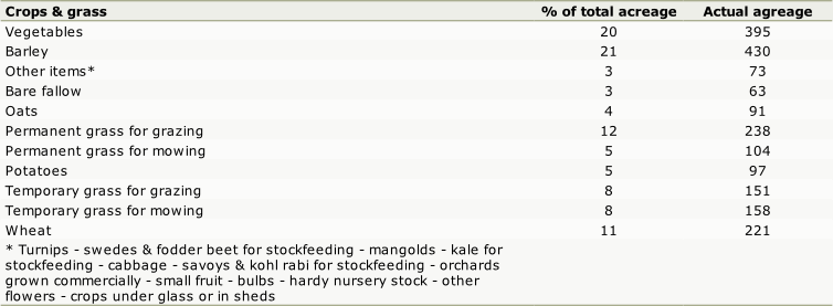
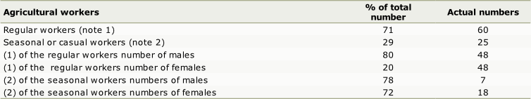
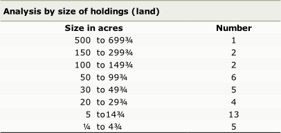
Woodborough’s agriculture is of two types, cereal and livestock farming, and market gardening. Out of a total of 2030 acres, 1,550 acres are under cereal and livestock farming and 450 acres under market gardening. In spite of the fact that ¾ of the acreage is under cereal and livestock farming there are only 15 holdings, as opposed to 21 which do market gardening. One can see from this that the cereal and livestock holdings are generally larger. This is because it is uneconomical to practise this type of farming on a small holding. Market gardening, on the other hand, can be very successful on holdings of only a few acres, as income per acre is very high. About half the total numbers of agricultural workers are employed in market gardening. This is due to the lack of mechanisation in market gardening compared with that in cereal and livestock farming.
Given below are the details of two farms, including tables of their main products, the number of acres devoted to them, and the average output. It must be noted that output varies considerably from year to year within one farm, because of weather and climatic change. Output also varies from farm to farm because of the different types of soil.
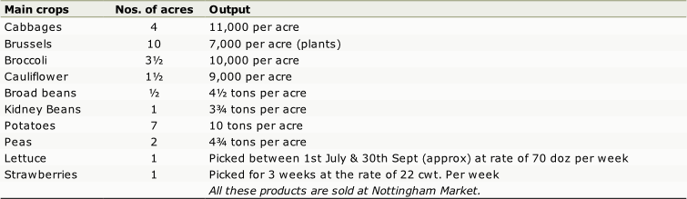
Firstly, there is a 32 acre farm which does market gardening. There are three full time workers and two part time who work for 6 months of the year.
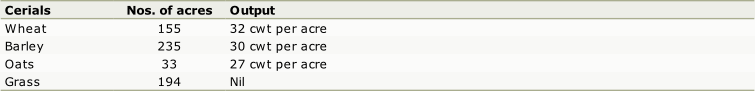
Secondly, there is a 617 acre cereal and livestock farm. However, only 210 acres are actually within the parish boundaries. Livestock figures for this farm, do, in some cases, exceed the total number of livestock for the parish (e.g. pigs), but this is because most of the livestock is kept in the neighbouring parish of Lambley. Eight workers are employed full time on the farm. Crop rotation is five consecutive years with cereals following by two years under grass for livestock.
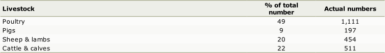
Livestock: 157 cattle, 325 pigs, 112 sheep – 100 ewes sheared once a year. Some of this livestock is sold at Nottingham Market and some to private buyers – as are all the cereal crops.
As well as livestock and cereal farming, and market gardening, there are two specialist holdings in the parish, one of which grows roses and the other, bulbs. These two holdings are at the eastern end of the parish, on the reddish clayey soils to the south of Lowdham Lane. The bulb holding covers ten acres, the rose holding 16 acres.
The soils of the parish fall under two main types (a) alluvial soils (b) clay soils. The former only occurs in the immediate vicinity of the four streams, Dover Beck and Grimesmoor Dyke, the other two not being named. The most extensive area of alluvial soils is in the north-east of the parish. The rest of the land is composed of clay soils. These clay soils are more fertile than the alluvial soils but they are much harder to drain. Several tile drainage schemes have been undertaken in recent years by farmers.
The figures for the following six lists were taken from the summary return sheet for June 1966.
The occupations of the population
The occupations of the villagers vary considerably, from scientists to hairdressers to secretaries. However, more general statements can be made. The male working population is about 40% of the total population, 350 out of 876. The rest of the population, 526, includes women, children and retired men. 50% of the working population work on the land of the Parish, 175 out of 350. 36% commute to Nottingham: 9% work in other parishes, mostly in the coal mine in Calverton: and 5% work in the shops of the Parish. With the future development of Woodborough, there are going to be less people on the land and a large increase in the number of people commuting to Nottingham.
Acknowledgement:
- Researched and written for a school project by C Wardle 1967
____________________________________________________________________________________________________
| Navigate this site |
| 001 Timeline |
| 100 - 114 St Swithuns Church - Index |
| 115 - 121 Churchyard & Cemetery - Index |
| 122 - 128 Methodist Church - Index |
| 129 - 131 Baptist Chapel - Index |
| 132 - 132.4 Institute - Index |
| 129 - A History of the Chapel |
| 130 - Baptist Chapel School (Lilly's School) |
| 131 - Baptist Chapel internment |
| 132 - The Institute from 1826 |
| 132.1 Institute Minutes |
| 132.2 Iinstitute Deeds 1895 |
| 132.3 Institute Deeds 1950 |
| 132.4 Institute letters and bills |
| 134 - 138 Woodborough Hall - Index |
| 139 - 142 The Manor House Index |
| 143 - Nether Hall |
| 139 - Middle Manor from 1066 |
| 140 - The Wood Family |
| 141 - Manor Farm & Stables |
| 142 - Robert Howett & Mundens Hall |
| 200 - Buckland by Peter Saunders |
| 201 - Buckland - Introduction & Obituary |
| 202 - Buckland Title & Preface |
| 203 - Buckland Chapter List & Summaries of Content |
| 224 - 19th Century Woodborough |
| 225 - Community Study 1967 |
| 226 - Community Study 1974 |
| 227 - Community Study 1990 |
| 400 - 402 Drains & Dykes - Index |
| 403 - 412 Flooding - Index |
| 413 - 420 Woodlands - Index |
| 421 - 437 Enclosure 1795 - Index |
| 440 - 451 Land Misc - Index |
| 400 - Introduction |
| 401 - Woodborough Dykes at Enclosure 1795 |
| 402 - A Study of Land Drainage & Farming Practices |
| People A to H 600+ |
| People L to W 629 |
| 640 - Sundry deaths |
| 650 - Bish Family |
| 651 - Ward Family |
| 652 - Alveys of Woodborough |
| 653 - Alvey marriages |
| 654 - Alvey Burials |
| 800 - Footpaths Introduction |
| 801 - Lapwing Trail |
| 802 - WI Trail |